Territorial landslide early warning systems (Te-LEWS)


AS1-Hong Kong, China
In the early 1970s, Hong Kong experienced a number of disastrous landslides, including the notable events in 1972 at Po Shan Road and Sau Mau Ping where 67 and 71 people died respectively. These catastrophes led to the establishment of the Geotechnical Control Office (now the Geotechnical Engineering Office (GEO) under the Civil Engineering and Development Department of Hong Kong) in 1977 to mitigate landslide risks and enforce slope safety (Cheung et al., 2006).
1.1 The setting
The Re LEWS was introduced by GEO in 1977 to alert the elements at risk of the possibility of landslide occurrences during prolonged heavy rainfall. Since 1984, the Re-LEWS is jointly operated by GEO and HKO. The early warning model is based on both the recorded and forecasted rainfall intensity in real-time. The recorded rainfall data was acquired by an extensive network of 110 automatic rain-gauge units over the territory, 86 of them operated by GEO and 24 by HKO (Fig. 1).

Figure 1: Rain-gauges location
The rainfall data are transmitted to the control centres at 5-minute intervals. Computer programs are developed to capture and analyze the real-time rainfall data in a rolling 24-hour period. In the current version of the LEW, the rainfall-landslide frequency models developed by Yu et al. 2003, are coded in the computer. While actual rainfall is required for deciding whether the warning criteria is reached or not, forecast rainfall is also desirable to give advance alert to HKO and GEO, as well as other government departments to mobilize resources to deal with the aftermaths of landslide incidents.
1.2 The modelling
Different landslide-rainfall correlations were used to define the thresholds for issuing the alerts, the first one was realized by Lump in 1975. This law related the occurrence of serious landslide events to 24-hour rainfall and antecedent rainfall in the previous 15-day. The purpose of landslip warning at that era was to provide a forewarning, particularly addressed to squatters, of rainfall situation which might lead to the onset of a significant number of landslips (Cheng et al. 2003).
In 1984 Brand et al., define thresholds based on the amounts of rainfall in 24 hours or the rainfall in one hour, using landslides and rainfall records over a 20-year period. The thresholds defined were largely adopted as the basis for the issuance of landslide alerts between mid-80s and late-90s. A substantial review of the alert criteria was carried out considering the study of Pun which established a linear relationship between the landslide density and the rolling 24-hour rainfall and proposed a new criterion based on the total number of predicted landslides over the territory. This refined correlation model was subsequently adopted in the Re-LEWS from 2000 to 2003. In 2003, Yu et al., introduced major changes: correlating maximum rolling 24-hour rainfall, R24*, with landslides frequency (i.e. failure probability), f , instead of landslide density (Pun et al., 2003); using analyzed rainfall values on grid cells; considering different slope types and hence different failure probabilities. In this model, the territory was divided up into 40×40 grid cells, each having a planar area of 1.5 km by 1.2 km. About 700 of these grid cells contain land area. The spatial distribution of different type of man-made slopes in each cell was determined from the GEO Catalogue of Slopes which registered all sizeable man-made slopes in Hong Kong (Fig. 2). A new set of bi-linear correlations between f and R24* in semi-log plot was determined for 4 common types of slopes in Hong Kong: soil cut slopes, rock cut slopes, fill slopes and retaining walls (Fig. 3), considering about 118 rainstorms in 1984-2001 with a maximum rolling 24-hour rainfall exceeding 50 mm.


Figure 2: Spatial distribution of man-made slopes (grayed areas) in Hong Kong. The grid lines indicate the discretization of the territory into 1,600 cells. (Cheung, LARAM 2013)
Figure 3: Failure frequency for the 4 different types of slopes. (Cheung, LARAM 2013)
1.3 The Warning strategy
Given a grid analysis of R24* (Fig. 4), the landslide frequencies for all the four slope types in a grid cell can be readily found according to the correlations (Fig. 3). The predicted number of landslides in a grid cell (N24,i) is calculated as the product of all the landslide frequencies multiplied by the number of slopes, n , in a cell (eq.1).
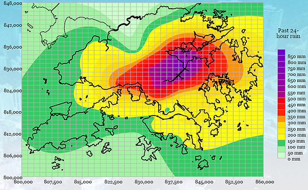
Figure 4: Rolling 24hours rainfall distribution. (Cheung, LARAM 2013)
The total number of predicted landslides for Hong Kong (N24) is obtained by summing over the number of landslides over all grid cells, i.e. N24 is the summation of f • n over all slope types (k) and all grid cells (eq. 1).

The alert is emitted when the predicted number of landslides (N24), in the Municipality of Hong Kong exceeds the threshold value (currently of 15).
Currently, HKO operates a nowcasting system named SWIRLS (Short-range Warning of Intense Rainstorms in Localized Systems) which provides quantitative precipitation forecast (QPF) at 1-hour and 3-hour as inputs to the LEW Model.
In essence, SWIRLS converts radar signal power into rainfall intensity using a dynamic correlation function, calibrated in real-time based on raingauge data. To make a very-short range forecast on the movement of the radar-rainfall, SWIRLS firstly derives their motion vectors by a technique called TREC (Tracking of Radar Echo by Correlation). Next, SWIRLS carries out a time integration from 0 to 3 hours by extrapolating the radar-rainfall field according to the TREC motion vectors in 6-minute time steps. At each time step, radar-rainfall is accumulated at each grid cell to generate the 1- to 3-hour forecast rainfall distributions over Hong Kong (Fig. 5).
To provide lead time before the alert criteria is reached as determined by the actual 24-hour accumulated rainfall, a EW module was developed in SWIRLS to make use of forecast rainfall to predict when the alert criteria (15 landslides) is likely to be reached. The SWIRLS Landslip Alert (SLA) module takes full account of the rainfall-landslide frequency correlation but uses the rolling 21-hour actual rainfall plus a 3-hour SWIRLS rainfall forecast to make up the rolling 24-hour rainfall (N21+3), thus providing a lead time of up to 3 hours. When the predicted number of landslides reaches the warning criteria (current 15), SWIRLS will provide visual and audio alarms to alert the forecasters (Fig. 5). It is worth noting that the issuance of the landslide alert and its timing are joint decisions of GEO and HKO with regard to additional factors, e.g. rainfall forecast.

Figure 5: Operational chart of the LEW Model. CFO (Central Forecasting Office of HKO). (Cheung et al., 2006)
1.4 The Response strategy
Decisions as to whether and when to issue or cancel the alert are made jointly by the Director of the HKO (Hong Kong Observatory) and the Head of the GEO. When the alert is emitted, a warning bulletin will be issued to the public immediately via media and internet. The television and radio will regularly advise the public to take appropriate precautionary measures and in case of serious situation, the public is advised to stay in a safe shelter or home.
1.5 Performance evaluation
Analyses on the efficiency of the EWM were carried out for 2001-2005 taking into account all SLA and landslide alerts issued in that period. The indicators, considered to analyze the performance, were: H (number of “hit”), F (number of “false alarm”), M (number of “miss”), N (total number of predictions = H+F), POD (probability of detection = H/(H+M)), FAR (false alarm ratio = F/(F+H)), CSI (critical success index = H/(H+M+F)), PIL (percentage of ideal lead time = actual lead time / ideal lead time) and the frequency distribution of different SLA lead times. For the SLA, a “false alarm” refers to an alert that the landslip warning criteria is expected to reach in the next 3 hours, i.e. N21+3 >15, but the landslip warning criteria is not reached in reality.
In Figure 6-a is shown the performance of the Landslide-rainfall correlations over the period 2001-05. The red lines mark the landslides threshold number used to set the alert criteria in the Landslip Warning System (15 landslides). The comparison of the landslide predictions by SWIRLS Landslip Alerts (i.e. N21+3) and the landslide-rainfall correlation model of GEO (i.e. N24 ) for cases in 2004-2006 (up to June) is presented in Figure 6-b where the red line indicates the perfect match between SWIRL alert and GEO. The obtained results showed that the EWM was generally effective and the SLA provides useful and timely guidance to forecasters.
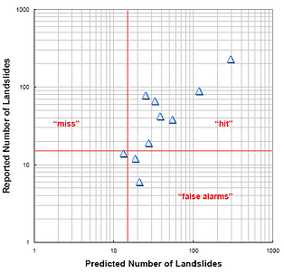
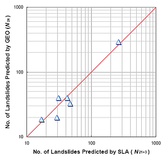
Figure 6: A) Performance of the Landslide-rainfall correlations over the period 2001-05. B) Comparison of the landslide predictions by SWIRLS Landslip Alerts and GEO. (Cheung et al., 2006)
References
Li, P.W. and E.S.T. Lai, 2005 : Typical Characteristics of Heavy Rain over Coastal Areas of Southern China – A Radar Perspective, Proceedings of Workshop on Meteorology and Climate over South China, 5-8 December 2005, City University of Hong Kong.
Lumb, P., 1975 : Slope failures in Hong Kong. Quarterly Journal of Engineering Geology, vol. 8, pp 21-65.
Brand E.W., J. Premchitt and H.B. Phillipson, 1984 : Relationship between rainfall and landslides in Hong Kong. Proceedings of the Fourth International Symposium on Landslides, Toronto, vol. 1, pp 377-384.
Pun, W.K., A.K.W. Wong and P.L.R. Pang, 2003 : A review of the relationship between rainfall and landslides in Hong Kong. Proceedings of the Asian Technical Committee (ATC 3) workshop on rain-induced landslides, Hong Kong, vol. 3, pp 211-217. (Published under the title Geotechnical Engineering Meeting Society's Needs, edited by Ho, K.K.S. & Li, K.S.).
Yu, Y.F., Lam, J.S., Siu, C.K. & Pun, W.K., 2004 : Recent advance in landslip warning system. Proceedings of the HKIE Geotechnical Division 24th Annual Seminar, Hong Kong, pp 139-147. (Published under the title Recent Advances in Geotechnical Engineering).
Cheung* P.Y., Wong M.C. & Yeung H.Y., 2006: Application of Rainstorm Nowcast to Real-time Warning of Landslide Hazards in Hong Kong. WMO PWS Workshop on Warnings of Real-Time Hazards by Using Nowcasting Technology, Sydney, Australia, 9-13 October 2006.
Information Note 02/2009. Landslip Warning System. Prepared by Standards and Testing Division Geotechnical Engineering Office Civil Engineering and Development Department March 2009.